
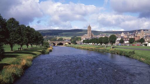
월커번
여행 가이드


월커번 여행 정보

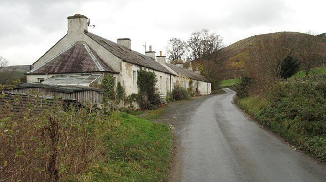
윈들스트로 게스트하우스
Galashiels Rd Walkerburn Scotland
8월 12일부터 8월 13일까지 요금은 1박당 ₩243,490입니다.
₩243,490
총 요금: ₩292,188
8월 12일 ~ 8월 13일
세금 및 수수료 포함
월커번에 있는 이 B&B에 숙박해 보세요! 무료 WiFi, 무료 주차, 아침 식사(요금 별도) 등의 편의 시설/서비스를 이용하실 수 있죠. 주변에 이너리스덴 골프 클럽, 로버트 스메일 프린팅 웍스 같은 인기 명소가 있어 관광을 즐기기에도 좋아요.
10/10 최고 좋음! (이용 후기 1개)
"After a long journey we were so pleased to stay at this B&B, we received a warm welcome, the building is beautiful with lovely views and our room was spotlessly clean and very comfortable. Breakfast was continental only but very well thought out and the communal areas are a special bonus. Would stay ..."
후기 작성 날짜: 2026년 5월 18일
달하우지 성
B704 Bonnyrigg Scotland
8월 31일부터 9월 1일까지 요금은 1박당 ₩491,214입니다.
₩491,214
총 요금: ₩589,457
8월 31일 ~ 9월 1일
세금 및 수수료 포함
보니리그의 출장 여행에 좋은 호텔입니다. 무료 아침 식사, 무료 WiFi, 무료 주차 등의 편의 시설/서비스를 이용하실 수 있죠. 특히 아침 식사, 친절한 고객 서비스 등이 고객들로부터 좋은 반응을 얻고 있습니다. 주변에 달하우지 성, 달키스 컨트리 파크 같은 인기 명소가 있어 관광을 ...
8.6/10 훌륭함! (이용 후기 816개)
멋진 경험
"매우 특별하고 훌륭한 경험이었습니다."
후기 작성 날짜: 2019년 10월 8일

드라이부르크 아베이 호텔
St Boswells Melrose Scotland
9월 1일부터 9월 2일까지 요금은 1박당 ₩189,208입니다.
₩189,208
총 요금: ₩227,049
9월 1일 ~ 9월 2일
세금 및 수수료 포함
멜로스에 있는 이 호텔에 숙박해 보세요! 무료 아침 식사, 무료 WiFi, 무료 주차 등의 편의 시설/서비스를 이용하실 수 있죠. 특히 친절한 고객 서비스 등이 고객들로부터 좋은 반응을 얻고 있습니다. 주변에 드라이버러 수도원, 스콧의 전망 같은 인기 명소가 있어 관광을 즐기기에도 ...
8.8/10 훌륭함! (이용 후기 923개)
"Peaceful"
후기 작성 날짜: 2026년 8월 1일
표시된 요금은 지난 24시간 이내 성인 2명 1박 기준 최저가입니다. 요금과 예약 가능 여부는 변경될 수 있으며, 추가 약관이 적용될 수 있습니다.

하비스톤 홀 에스테이트 룸
Harvieston Estate Gorebridge Scotland
고어브리지에 있는 이 아파트식 호텔에 숙박해 보세요! 무료 주차, 정원 등의 편의 시설/서비스를 이용하실 수 있죠. 주변에 보스윅 성, 고어 글랜 우드랜드 파크 같은 인기 명소가 있어 관광을 즐기기에도 좋아요.
6/10 (이용 후기 5개)
"We arrived late to the accommodation, having informed the hosts in advance. Access directions were accurate . The ‘old’ house is not in a good state of repair and Flat 7b requires serious cleaning and decor repair . The carpets were heavily stained, as was the sofa (to the point of not using it), ..."
후기 작성 날짜: 2026년 7월 25일

퍼스트 라스웨이드 로드 하우스
Lasswade Road Edinburgh Scotland
에든버러의 출장 여행에 좋은 빌라입니다. 무료 WiFi, 무료 주차, 24시간 운영 프런트 데스크 등의 편의 시설/서비스를 이용하실 수 있죠. 특히 숙박 시설 상태 등이 고객들로부터 좋은 반응을 얻고 있습니다. 주변에 로얄 마일, 에든버러 성 같은 인기 명소가 있어 관광을 즐기기에도 ...
6.8/10 (이용 후기 5개)
"The property was unfortunately not as advertised and the photos felt very misleading. While the bedding, kitchen and bathroom were clean, overall the place felt quite tired and in need of an upgrade. The walls, carpets and couches all needed a proper clean and there were no base covers on the bed. ..."
후기 작성 날짜: 2026년 5월 10일

고어브리지의 평화로운 리트리트
Gorebridge Scotland
고어브리지에 있는 이 별장에 숙박해 보세요! 무료 WiFi, 정원, 객실 내 세탁기/건조기 등의 편의 시설/서비스를 이용하실 수 있죠. 주변에 달하우지 성, 보스윅 성 같은 인기 명소가 있어 관광을 즐기기에도 좋아요.
표시된 요금은 지난 24시간 이내 성인 2명 1박 기준 최저가입니다. 요금과 예약 가능 여부는 변경될 수 있으며, 추가 약관이 적용될 수 있습니다.


